中文
  • Home
  • Intelligent Traffic
    • Air Traffic Management & Airport Management
      • Air Traffic Management
      • Airport Management
      • CNS Related Equipment
    • Urban Traffic Management
      • Traffic Management And Control Platform
      • UTMS Related Equipment
    • Vessel Traffic Management
  • Smart Governance
    • Smart Govenance Solutions
    • Emergency Management
    • Command Communication Vehicle
    • Satellite Communications
    • High Resolution Remote Sensing Satellite
  • Virtual Exhibition Hall
  • International Cooperation
  • About Us
    • Company Overview
    • R&D Strength
    • Service
    • Company News
    • Contact Us
    • Typical Cases
    • Download Center
Back
ADS-B Ground Station and Multilateration(ADS-B & MLAT)
The ADS-B system station receives and processes the ADS-B signal broadcasted by aircrafts or operation vehicles in real time. Extracts target surveillance information through decoding, error correction and related tracking processing, which include identification information (Mode A, 24-bit address code, call sign ID), location (latitude, longitude, altitude), speed and intention information, etc. And provides high precision real time information services for the surveillance and management operations of controllers and airlines.
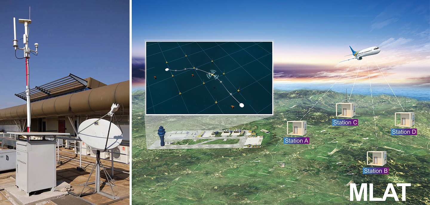
The MLAT system uses the time difference of arrival (TDOA) of the signal received by the base station to realize accurate, reliable and real time positioning (latitude, longitude, altitude) and identification (Mode A, 24-bit address code, call sign ID) of aircrafts, operation vehicles or other targets with mode A/C/S signal transmission capabilities. And provides high precision real time information services for the surveillance and management operations of controllers and airlines.
 
 
Back
Quick links
  • Intelligent Traffic
    • Air Traffic Management & Airport Management
    • Urban Traffic Management
    • Vessel Traffic Management
  • Smart Governance
    • Smart Govenance Solutions
    • Emergency Management
    • Command Communication Vehicle
    • Satellite Communications
    • High Resolution Remote Sensing Satellite
  • Virtual Exhibition Hall
  • International Cooperation
  • About Us
    • Typical Cases
    • Download Center
    • Company Overview
    • R&D Strength
    • Service
    • Company News
    • Contact Us
  • Download Center
Newsletter
send
Get In Touch
Download Center
(+86) -25-82285885
Asia and the Pan Pacific Region: [email protected][email protected]
Africa, Middle East and Indian Ocean Region: [email protected]
COPYRIGHT © Nanjing LES Information Technology Co., Ltd.
  • Home
  • Intelligent Traffic
    • Air Traffic Management & Airport Management
      • Air Traffic Management
      • Airport Management
      • CNS Related Equipment
    • Urban Traffic Management
      • Traffic Management And Control Platform
      • UTMS Related Equipment
    • Vessel Traffic Management
  • Smart Governance
    • Smart Govenance Solutions
    • Emergency Management
    • Command Communication Vehicle
    • Satellite Communications
    • High Resolution Remote Sensing Satellite
  • Virtual Exhibition Hall
  • International Cooperation
  • About Us
    • Company Overview
    • R&D Strength
    • Service
    • Company News
    • Contact Us
    • Typical Cases
    • Download Center